The Unintended Blues
“The future choices we make about our coasts and oceans are not just technical decisions about peripheral matters. They are decisions about who we are, what we value, what kind of world we want to live in—the world our children and grandchildren will inherit. The stakes are very high.”
-Gary Griggs, Professor of Earth and Planetary Sciences, and Director of the Institute of Marine Sciences, UC Santa Cruz
The root causes of sea level rise are as complex, nuanced and dynamic as are the debates about our part in its acceleration and remediation. In the last 150 years, coastal cities have gone from agricultural centers and ports of trade to destinations for leisure and full-time retirement, which has put enormous stress on the environment and the communities that inhabit them, human, plant and animal. According to the UN, by 2050 more than 3 billion people are expected to live in port cities built on low lying elevations with an increased risk of rising sea levels, severe storm-surge flooding, damage from high storm winds, and land subsidence. By 2070, 20 of the 130 largest global port cities like New York, Miami and Los Angeles will have approximately 88 million people at risk.
A 2024 article in Nature reported that the United States has more than 30% of its population residing in coastal cities, generating an estimated annual revenue of US $3.8 trillion, and consequently, significant socioeconomic losses from climate-induced sea level rise.
Artists are in a unique position to bring awareness to issues of great urgency like this by reaching the hearts and minds of viewers, not just with information but with the poetic force of their creativity.
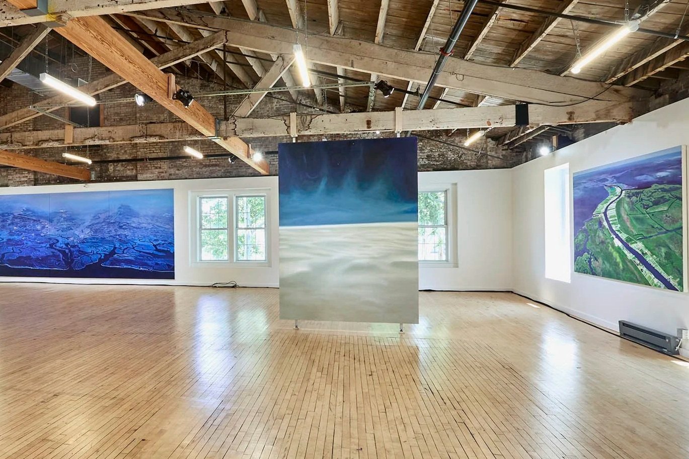
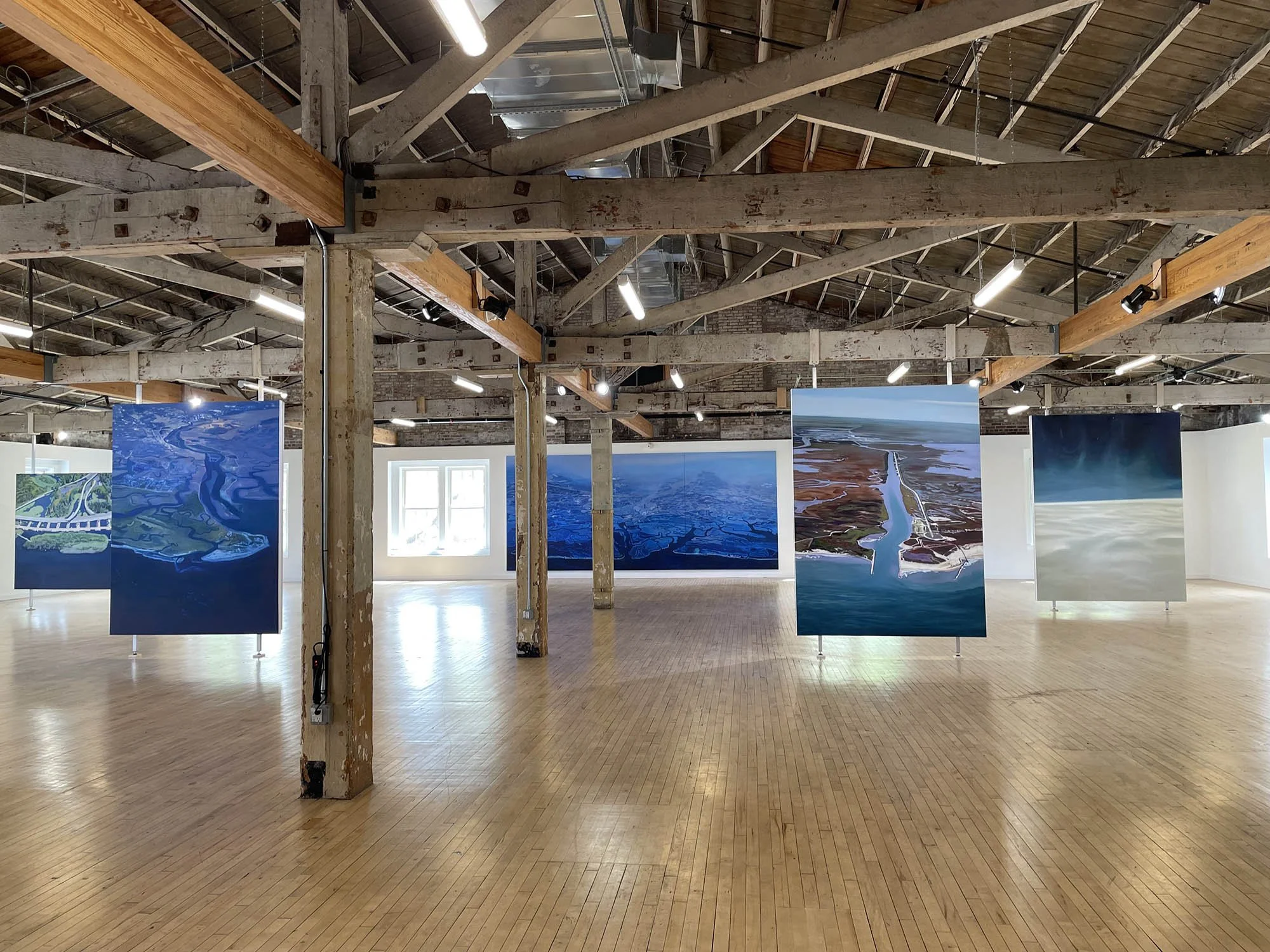
The genesis of The Unintended Blues project began in early 2024 when, flying back from a trip to the Yucatan one evening, I looked out my window and saw the extraordinary patterns formed by the infiltrating tributaries of the Chesapeake Bay. I was immediately struck not only by its beauty, but by the graphic clarity of one of our greatest existential threats – that of rising sea levels. I took numerous photos and knew that these would become source material for future paintings. Over time, as I read more deeply about our coastlines and about the various factors that contribute to their rapid change, I decided to embark on a project to document vulnerable shorelines on all three coasts of the Continental US through aerial landscape paintings, which ended up including images of Washington, California, Texas, Louisiana, Virginia, New York and New Jersey. I later added a series of paintings based on photographs of melting icebergs in the Northwest Passage near Greenland. These paintings portray the splendor of what we stand to lose by our inaction.
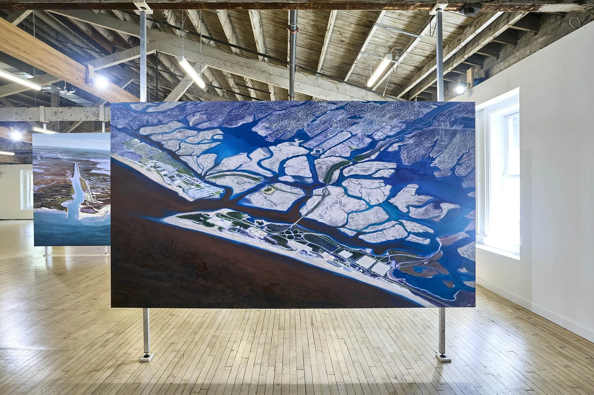
This project debuted at the Lower Manhattan Cultural Council Arts Center on Governor’s Island in the summer of 2026 as part of their River to River Festival and also includes three multi-media works, where I explore not just the visual, but sound, moving image, sculpture, and audience participation in order to bring these issues more palpably forward.
Below is information about each work in the exhibition. Please refer to the Works page to match titles and information to their respective images.
The Unintended Blues,
2024, oil on canvas, 100 x 234 inches
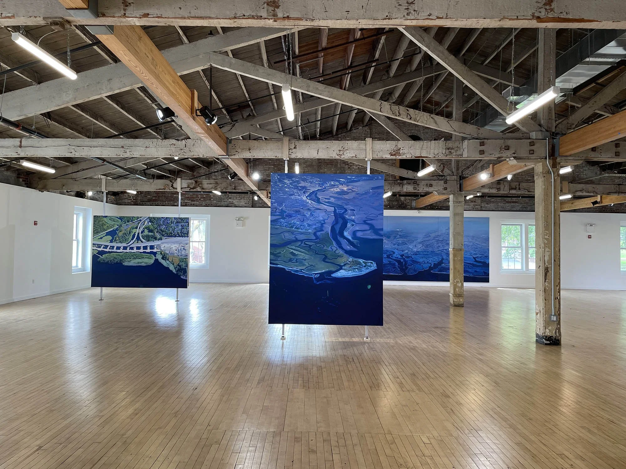
This painting is based on a composite of several photos taken from an airplane window while flying over the Chesapeake Bay. Located in the Mid-Atlantic region, the Chesapeake Bay watershed is the largest estuary in the United States with a vast area of over 64,000 square miles that drains into the Bay, encompassing parts of Delaware, Maryland, New York, Pennsylvania, Virginia, West Virginia and Washington DC. This huge land to water ratio means that land use around it significantly impacts the Bay’s health. More than 150 major rivers and streams flow into the Bay’s drainage basin. It is approximately 200 miles long and 2.8 miles wide at its narrowest and 20 miles at its widest. The Chesapeake Bay serves as a vital artery for trade, sustenance and culture but has suffered environmental decline due to nutrient pollution, urban runoff, over-harvesting of shellfish, climate change and sea level rise.
Chesapeake, 2025, oil on canvas, 100 x 75 inches
This painting focuses on a closer view of urban development in the Chesapeake Bay area. Located in the Mid-Atlantic region, the Chesapeake Bay watershed is the largest estuary in the United States with a vast area of over 64,000 square miles that drains into the Bay, encompassing parts of Delaware, Maryland, New York, Pennsylvania, Virginia, West Virginia and Washington DC. This huge land to water ratio means that land use around it significantly impacts the Bay’s health. More than 150 major rivers and streams flow into the Bay’s drainage basin. It is approximately 200 miles long and 2.8 miles wide at its narrowest and 20 miles at its widest. The Chesapeake Bay serves as a vital artery for trade, sustenance and culture but has suffered environmental decline due to nutrient pollution, urban runoff, overharvesting of shellfish, climate change and sea level rise.
Matagorda, 2025, oil on canvas, 102 x 75 inches
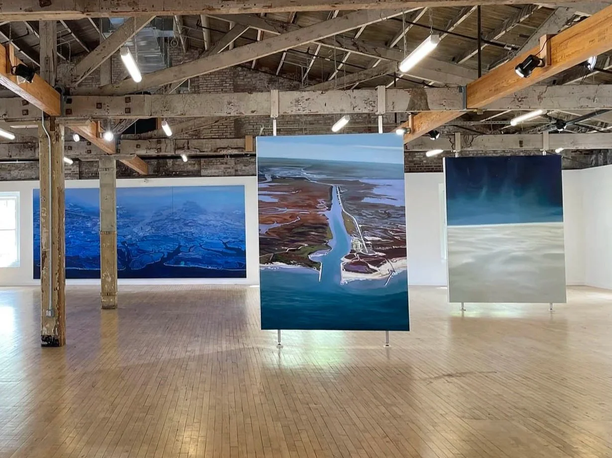
Matagorda Beach lies on a thin strip of sand at the mouth of the Colorado River located along the central Texas coast and separates the Matagorda Bay and East Matagorda Bay from the Gulf. The Matagorda Bay system is part of the second-largest estuary in Texas, and is where two major plastics manufacturers, Formosa Plastics and Dow Chemical operate. A 2025 study has documented high levels of pollution from micro plastic pellets which are being washed out to sea.
Lafitte, 2025, oil on canvas, 67 x 118 inches
The town of Jean Lafitte, Louisiana is one of the many multi-generational communities in the Barataria Basin, a major wetland area south of New Orleans surrounded by marshes and swamps that make up the Barataria-Terrebonne Estuary. It is bounded by the Mississippi River to the northeast and the Barataria Bay to the South. It faces severe environmental threats driven by rapid coastal land loss, intense hurricanes and rising sea levels. The community deals with chronic flooding, land subsidence (sinking) and saltwater intrusion that are destroying wetlands and threatening the local fishing economy. The entire Gulf coast’s hydrology has been severely altered by canal excavation for oil and gas pipelines that connect to thousands of offshore drilling rigs. In November 2025, the Interior Department finalized an offshore drilling plan for three sales in the Gulf over the next five years, signaling a massive expansion of offshore drilling into the year 2040.
Paved Paradise, 2025, oil on canvas, 75 x 102 inches
This image depicts a development site on the edge of Lake Washington in the Northeast part of Seattle and comes from a 2016 photo taken as part of a government study monitoring coastal erosion in Washington State. The title refers to Joni Mitchell’s famous 1970s hit song “Big Yellow Taxi” in which she sings “they paved paradise and put up a parking lot.”
Calleguas Creek, 2025, oil on canvas, 75 x 100 inches
Calleguas Creek is the terminus of a river system in Southern California, critically draining the Calleguas Creek Watershed, an area approximately 30 miles long and 14 miles wide, into the Mugu Lagoon and Pacific Ocean. It is managed for water quality since it faces impairments from nutrients, pesticides and metals. It is also a major saltwater marsh supporting significant bird biodiversity. Historically, the Creek and its tributaries were all intermittent streams that only flowed seasonally. Due to development, it is now primarily a perennial stream, mostly fed continuously by treated wastewater flows, with secondary surface flows of rising groundwater, agricultural and urban runoff, and periodic stormwater.
Crossing Currents, 2025, oil on canvas, 67 x 157 ½ inches
Crossing Currents shows the intersection of the Hudson and East rivers, where the tip of Manhattan, Brooklyn, and New Jersey meet Governor’s Island, Ellis Island and the Statue of Liberty. Both rivers are tidal estuaries, where fresh water meets seawater, that reverse direction roughly every six hours based on the tides. The Hudson flows south during low tide and north during rising tide, while the East River flows south during low tide and north during high tide. It is part of the larger Hudson-Raritan Estuary, a highly dynamic urbanized tidal estuary and in spite of ecological challenges due to industrial impacts and sea level rise, it is a nutrient rich environment of tidal marshes, rocky intertidal zones and oyster reefs that support a biodiverse ecosystem of birds, shorebirds and specialized aquatic species like comb jellies, eel, blue crab, striped bass and waterfowl. However, the large percentage of developments built along these shores remain extremely vulnerable to rising sea levels.
Red Tide on Robert’s Pride, 2025, oil on canvas, 67 x 118 inches
Robert’s Pride refers to Long Island State Park Commissioner Robert Moses and his expansive development of Long Island, including the creation of Robert Moses State Park in 1929. While the Park preserves miles of natural shoreline, dunes and salt marshes on the Atlantic Ocean and South Shore Estuary, the development of parkways leading to it has had a major impact on local ecosystems, with some projects leading to the destruction of wetlands and creation of water runoff issues. This view shows Jones Beach, which is part of Robert Moses State Park, on the lower right and Point Lookout to its left, with a series of interconnecting highways to Long Island above. Red tides are common in Long Island waters and are driven by unusually high nitrogen levels from wastewater, leading to “rust tides” of explosive algae blooms that release potent toxins lethal to fish and shellfish and can pose serious public health threats. Red tides can last from weeks to over a year.
Ascent, 2024, oil on canvas, 110 x 82 inches
Ascent is based on a photograph Wayne took of the night sky flying above the clouds while heading up the Northeast Atlantic coast. While not an image of a shoreline or of water per se, it is nevertheless connected, for the clouds are the vapors of our oceans. It also reminds us that the atmosphere above our earth is a powerful indicator of the health of our planet.
Approaching Kiatassuaq Island, 2025, oil on canvas, 75 x 100 inches
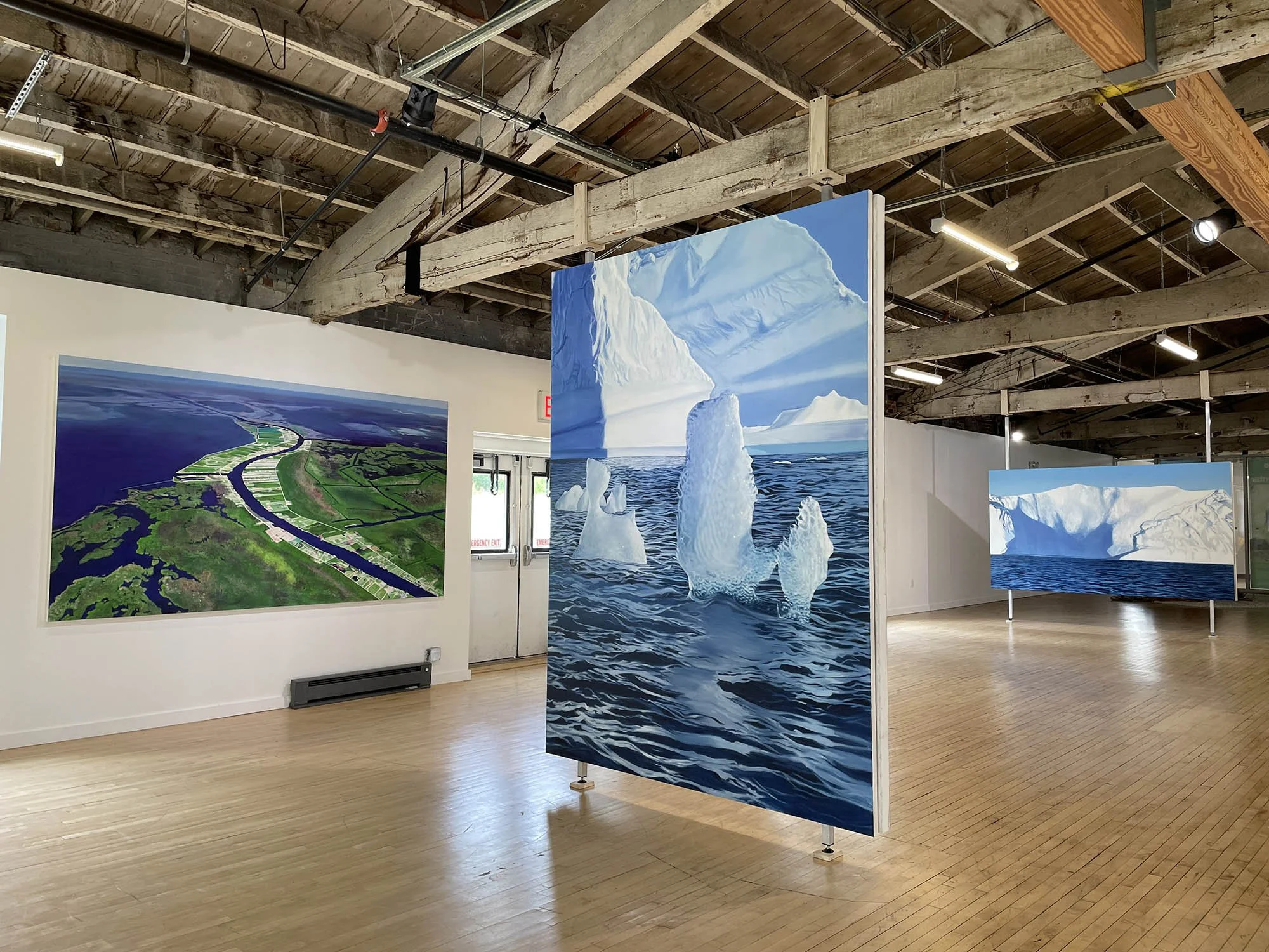
Kiatassuaq Island is in northwest Greenland at the southern border of Melville Bay. Well within the Arctic Circle where the ice sheet meets the sea, Melville Bay is characterized by enormous glaciers, massive icebergs and fields of pack ice all year round. Melville Bay is an active glacial sector, and its contribution to the overall Greenland ice sheet’s accelerated mass loss is 20% faster than predicted. The rapid melting is largely caused by warmer ocean water reaching the base of the glaciers, thinning the ice in some regions by up to 250 feet per year. Overall, the Melville Bay region is a key area of concern with accelerating dynamic ice loss. Kiatassuaq Island means “a large torso” in Greenlandic. It is an uninhabited island in the northern Upernavik Archipelago in northwestern Greenland and marks the southern border of the massive Melville Bay. It has been an important area for marine hunting for the local indigenous communities since the 19 th century. The threat of resource extraction projects, climate driven changes in animal migration, such as rapidly melting sea ice and glaciers, have increasingly restricted access to traditional food sources and subsistence-based culture and lifestyle.
Melville Bay, 2025, oil on canvas, 110 x 82 inches
Well within the Arctic Circle where the ice sheet meets the sea, Melville Bay is characterized by enormous glaciers, massive icebergs and fields of pack ice all year round. Melville Bay is an active glacial sector, and its contribution to the overall Greenland ice sheet’s accelerated mass loss is 20% faster than predicted. The rapid melting is largely caused by warmer ocean water reaching the base of the glaciers, thinning the ice in some regions by up to 250 feet per year. Overall, the Melville Bay region is a key area of concern with accelerating dynamic ice loss.
Melville Bay, 2, 2026, oil on canvas, 67 x 118 inches
Well within the Arctic Circle where the ice sheet meets the sea, Melville Bay is characterized by enormous glaciers, massive icebergs and fields of pack ice all year round. Melville Bay is an active glacial sector, and its contribution to the overall Greenland ice sheet’s accelerated mass loss is 20% faster than predicted. The rapid melting is largely caused by warmer ocean water reaching the base of the glaciers, thinning the ice in some regions by up to 250 feet per year. Overall, the Melville Bay region is a key area of concern with accelerating dynamic ice loss.
Griese Fjørd, 2026, oil on canvas, 100 x 75 inches
Griese Fjørd’s Inuktitut name is Aujuittuq, meaning “the place that never thaws.” It is Canada’s northernmost civilian community located on the southern edge of Ellesmere Island in Nunavut known for its cold arctic climate with an average annual temperature of 2.3° F and 24-hour summer sunlight. Griese Fjørd faces severe environmental challenges driven by rapid Arctic warming, increased coastal erosion, unpredictable sea ice, rising sea levels and stronger storms. Reduced sea ice safety due to late season ice forming is limiting safe hunting and travel routes for Inuit residents. With a rapidly warming Arctic environment, ecosystems and biodiversity are being disrupted, impacting habitat for local species.
Kiatassuaq Island, 2025, oil on canvas, 75 x 102 inches
Kiatassuaq Island means “a large torso” in Greenlandic. It is an uninhabited island in the northern Upernavik Archipelago in northwestern Greenland and marks the southern border of the massive Melville Bay. It has been an important area for marine hunting for the local indigenous communities since the 19 th century. The threat of resource extraction projects, climate driven changes in animal migration, such as rapidly melting sea ice and glaciers, have increasingly restricted access to traditional food sources and subsistence-based culture and lifestyle.
De Dødes Fjørd, Kap York, 2026, oil on canvas, 102 x 75 inches
De Dødes Fjørd means “The Fjørd of the Dead” in Danish, generally thought to be because of its bleak, desolate and dangerous topography of glaciated plateaus, treacherous shifting ice, and harsh environment. It lies in northwestern Greenland, near the “Crimson Cliffs,” a region with a long history of Thule and Inuit presence. The Inuit believe the area holds deep spiritual significance associated with the spirits of ancestors and the “inua” (human owners) of the landscape.
Swept Away, 2025-2026, used marine line, wooden spool, video. Size variable.
Marine tug lines represent the most basic tool used to tow in and moor items ripped away in extreme flooding conditions. Tug lines are specialized high strength ropes, commonly nylon or polyester, which have high elasticity, are resistant to abrasion and are stronger than steel. Hemp ropes are considered the strongest natural fiber available and are making a resurgence for their eco-friendly sustainability, their durability, resistance to saltwater and high tensile strength.
Submerging, 2025 – 2026, video, 13-minute continuous loop
The lapping seawater immerses the viewer in the hypnotic rhythm of the tide and the foreboding encroachment of rising flood waters. This footage was taken in the waters of South Brooklyn near Sheepshead Bay. Message in a Bottle to Congress, 2026, glass bottle, poster, table, pens, paper A list of 78 science and climate-based words culled from the over 350 words and phrases banned by the Federal Administration serves as an invitation to viewers to express their own thoughts on paper about the climate debate today and the importance of science. Their words will become an integral part of this work in perpetuity and a permanent record of public opinion in the summer of 2026.